Image courtesy Wikimedia Commons
Last week, I got an email I’ve been waiting to receive for...I honestly don’t know how long!
It was from the Digital Initiatives and Services department of The Newberry in Chicago. At first I thought it was another “We’re still working on it” update, but no. While not officially relaunched, they wanted to let those of us on the mailing list know that the AHCB interactive maps are BACK!
Whoo-hoo! Hot diggity!
You may wonder, “What’s the big deal? And what in the world is the AHCB?”
AHCB stands for: Atlas of Historical County Boundaries. To quote the website: “The Atlas presents ... the creation and all subsequent changes (dated to the day) in the size, shape, and location of every county in the fifty United States and the District of Columbia.” [1]
It’s a big deal because the AHCB is a wonderful interactive tool that often can help a genealogist find an individual who suddenly disappears. Let me give you an example:
Let us say you have tracked “Joe Blow” back, via census and tax records, to 1801. He resides in Madison County, Kentucky. However, in 1800, you can’t find him in Madison County. Tax records have him in there in 1809, 1808, 1807, etc. then, poof! He isn’t on the 1800 or preceding Madison County tax lists. Where’d Joe go?
Actually, the question should be, “Where did Joe come from in 1800 or 1801?”
The answer honestly may be, “Nowhere. He never moved—was born, raised and died in the same house.”
“What? No way! Then why isn’t he on any of the tax lists prior to 1801?”
Simple. He is.
“Wait, WHAT?”
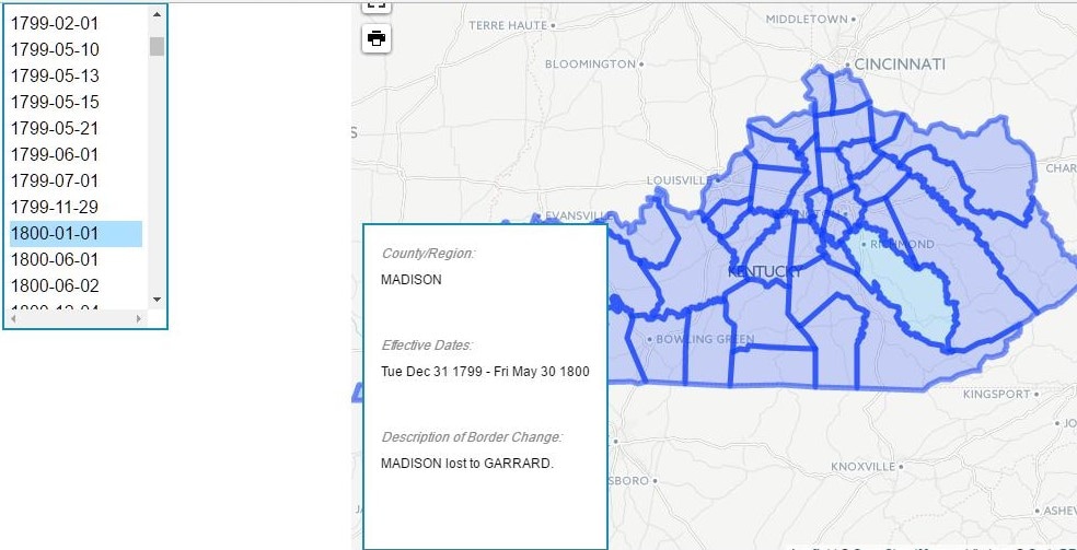
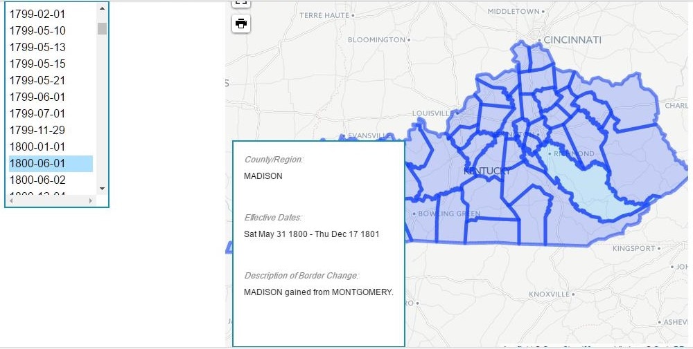
The part of Madison County where Joe lived was actually Montgomery County before Madison County “gained” it as the result of a 1799 act of the Kentucky Legislature. The resulting boundary change due to Madison’s gain explains how Joe moved without moving. The comparison maps below show Madison County's gain. A check of Montgomery County tax lists for 1800 shows Joe, as do the 1799 and 1798 tax lists.
It was from the Digital Initiatives and Services department of The Newberry in Chicago. At first I thought it was another “We’re still working on it” update, but no. While not officially relaunched, they wanted to let those of us on the mailing list know that the AHCB interactive maps are BACK!
Whoo-hoo! Hot diggity!
You may wonder, “What’s the big deal? And what in the world is the AHCB?”
AHCB stands for: Atlas of Historical County Boundaries. To quote the website: “The Atlas presents ... the creation and all subsequent changes (dated to the day) in the size, shape, and location of every county in the fifty United States and the District of Columbia.” [1]
It’s a big deal because the AHCB is a wonderful interactive tool that often can help a genealogist find an individual who suddenly disappears. Let me give you an example:
Let us say you have tracked “Joe Blow” back, via census and tax records, to 1801. He resides in Madison County, Kentucky. However, in 1800, you can’t find him in Madison County. Tax records have him in there in 1809, 1808, 1807, etc. then, poof! He isn’t on the 1800 or preceding Madison County tax lists. Where’d Joe go?
Actually, the question should be, “Where did Joe come from in 1800 or 1801?”
The answer honestly may be, “Nowhere. He never moved—was born, raised and died in the same house.”
“What? No way! Then why isn’t he on any of the tax lists prior to 1801?”
Simple. He is.
“Wait, WHAT?”
The part of Madison County where Joe lived was actually Montgomery County before Madison County “gained” it as the result of a 1799 act of the Kentucky Legislature. The resulting boundary change due to Madison’s gain explains how Joe moved without moving. The comparison maps below show Madison County's gain. A check of Montgomery County tax lists for 1800 shows Joe, as do the 1799 and 1798 tax lists.
 |  |
While a county formation list usually does NOT include boundary changes, the AHCB provides a map or polygon and text detail for each boundary change, and cites the source! Below is a screenshot from the ACHB website[2]:
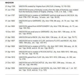
Kentucky: Individual County Chronologies
Madison County’s boundaries changed ELEVEN times after it was formed!
In our example of Joe, if he was a real person and if the tax records are still extant, you would find he paid taxes in Clark County before it was Montgomery and would have paid in either Bourbon or Fayette before that.
See how helpful ACHB might be for you in your genealogical research?
Happy mapping!
[1]http://publications.newberry.org/ahcbp/project.html : accessed 16 April 2017.
[2]http://publications.newberry.org/ahcbp/documents/KY_Individual_County_Chronologies.htm#Individual_County_Chronologies : accessed 16 April 2017.
 RSS Feed
